Portal:Tropical cyclones
The Tropical Cyclones Portal
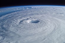
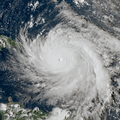
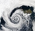
A tropical cyclone is a storm system characterized by a large low-pressure center, a closed low-level circulation and a spiral arrangement of numerous thunderstorms that produce strong winds and heavy rainfall. Tropical cyclones feed on the heat released when moist air rises, resulting in condensation of water vapor contained in the moist air. They are fueled by a different heat mechanism than other cyclonic windstorms such as Nor'easters, European windstorms and polar lows, leading to their classification as "warm core" storm systems. Most tropical cyclones originate in the doldrums, approximately ten degrees from the Equator.
The term "tropical" refers to both the geographic origin of these systems, which form almost exclusively in tropical regions of the globe, as well as to their formation in maritime tropical air masses. The term "cyclone" refers to such storms' cyclonic nature, with anticlockwise rotation in the Northern Hemisphere and clockwise rotation in the Southern Hemisphere. Depending on its location and intensity, a tropical cyclone may be referred to by names such as "hurricane", "typhoon", "tropical storm", "cyclonic storm", "tropical depression" or simply "cyclone".
Types of cyclone: 1. A "Typhoon" is a tropical cyclone located in the North-west Pacific Ocean which has the most cyclonic activity and storms occur year-round. 2. A "Hurricane" is also a tropical cyclone located at the North Atlantic Ocean or North-east Pacific Ocean which have an average storm activity and storms typically form between May 15 and November 30. 3. A "Cyclone" is a tropical cyclone that occurs in the South Pacific and Indian Oceans.
Selected named cyclone -
Severe Tropical Cyclone Seroja was the third-deadliest tropical cyclone on record in the Australian region, behind Cyclone Mahina in 1899 and the Flores cyclone in 1973. Seroja brought historic flooding and landslides to portions of southern Indonesia and East Timor and later went on to make landfall in Western Australia's Mid West region, becoming the first to do so since Cyclone Elaine in 1999. The twenty-second tropical low, seventh tropical cyclone, and third severe tropical cyclone of the 2020–21 Australian region cyclone season, the precursor of Seroja formed off the south coast of Timor island as Tropical Low 22U at 18:00 UTC on 3 April 2021; its genesis was related to convectively coupled equatorial waves. The tropical low moved very slowly near the island, while the system's thunderstorms increased in organization. The low intensified into Tropical Cyclone Seroja by 4 April, while it was passing north of Rote Island, while continuing its slow strengthening trend.
Due to the presence of Tropical Cyclone Odette in Seroja's vicinity, interaction was anticipated as the storm moved away from Indonesia and East Timor. Its intensity fluctuated as it moved southwest, with its strengthening being highly hindered due to interaction with Odette. This caused the system to weaken as Seroja moved closer to it, due to a phenomenon known as the Fujiwhara effect. Eventually, Seroja began to restrengthen and weaken Odette, with Seroja absorbing Odette into its circulation on 10 April. Due to Odette, Seroja was steered to the southeast towards Australia, before strengthening even further. At around 8 p.m. local time on 11 April, Seroja made landfall on the western coastline of Western Australia as a Category 3 severe tropical cyclone, slightly south of the coastal town of Kalbarri, bringing heavy rain and hurricane-force wind gusts (about 170 km/h, or 110 mph). Later that day, Seroja began accelerating southeastward while weakening. On 12 April, Seroja emerged off the southern coast of Western Australia while beginning to undergo an extratropical transition, before being absorbed into another larger extratropical cyclone to the south. The name Seroja means lotus in Indonesian. (Full article...)Selected article -
Paleotempestology is the study of past tropical cyclone activity by means of geological proxies as well as historical documentary records. The term was coined by American meteorologist Kerry Emanuel.
The usual approach in paleotempestology is the identification of deposits left by storms. Most commonly, these are overwash deposits in waterbodies close to the coast; other means are oxygen isotope ratio variations caused by tropical cyclone rainfall in trees or speleothems (cave deposits), and identifying beach ridges kicked up by storm waves. The occurrence rate of tropical cyclones can then be inferred from these deposits and sometimes also their intensity – typically the stronger events are the most easily recognizable ones –, by comparing them to deposits left by historical events. (Full article...)Selected image -

Selected season -

The 2015 Pacific hurricane season is the second-most active Pacific hurricane season on record, with 26 named storms, only behind the 1992 season. A record-tying 16 of those storms became hurricanes, and a record 11 storms further intensified into major hurricanes throughout the season. The Central Pacific, the portion of the Northeast Pacific Ocean between the International Date Line and the 140th meridian west, had its most active year on record, with 16 tropical cyclones forming in or entering the basin. Moreover, the season was the third-most active season in terms of accumulated cyclone energy, amassing a total of 290 units. The season officially started on May 15 in the Eastern Pacific and on June 1 in the Central Pacific; they both ended on November 30. These dates conventionally delimit the period of each year when most tropical cyclones form in the Northeast Pacific basin. However, the formation of tropical cyclones is possible at any time of the year. This was shown when a tropical depression formed on December 31. The above-average activity during the season was attributed in part to the very strong 2014–2016 El Niño event.
The season featured several long-tracking and powerful storms, although land impacts were often minimal. In June, Hurricane Blanca, an early season Category 4 hurricane, killed four people due to rough seas. Hurricane Carlos caused minor damage while passing a short distance off the coast of Mexico. In July, the remnants of Hurricane Dolores brought record rainfall to Southern California, killing one and causing losses worth over $50 million. On August 29, three Category 4 hurricanes (Kilo, Ignacio, Jimena) were all active simultaneously in the Pacific east of the International Date Line for the first time in recorded history. In September, moisture from Hurricane Linda contributed to storms that killed 21 people in Utah. Later that month, Hurricane Marty inflicted $30 million in damage to the southwestern coast of Mexico. In October, Hurricane Patricia became the most intense hurricane ever recorded in the Western Hemisphere, with a central pressure of 872 mbar (hPa; 25.75 inHg) and 1-minute sustained winds of 215 mph (345 km/h). After also becoming the strongest landfalling Pacific hurricane on record at the time, Patricia claimed 13 lives and was responsible for $463 million in damage. The season's activity continued into November when Hurricane Sandra became the strongest Pacific hurricane ever recorded in that month. Damage across the basin reached $566 million, while 45 people were killed by the various storms. (Full article...)Related portals
Currently active tropical cyclones

Italicized basins are unofficial.
- North Atlantic (2024)
- No active systems
- East and Central Pacific (2024)
- No active systems
- West Pacific (2024)
- No active systems
- North Indian Ocean (2024)
- No active systems
- Mediterranean (2023–24)
- No active systems
- South-West Indian Ocean (2023–24)
- No active systems
- Australian region (2023–24)
- No active systems
- South Pacific (2023–24)
- No active systems
- South Atlantic (2023–24)
- No active systems
Last updated: 21:54, 8 May 2024 (UTC)
Tropical cyclone anniversaries
May 18
- 1986 - Cyclone Namu moved through the Solomon Islands, killing at least 111 people.
- 1997 - A powerful cyclone made landfall over in Bangladesh as a powerful Category 4 cyclone, killing more than 1,150 people.
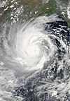
- 2020 - Cyclone Amphan (pictured) reached peak intensity as a Category 5 super cyclonic storm, and two days later moved ashore near the border of India and Bangladesh. With an estimated US$13.7 billion in damages, Amphan was the costliest North Indian Ocean tropical cyclone on record.

May 19
- 1997 - A powerful cyclone (pictured) struck Bangladesh, killing 1,146 people.
- 2004 - A cyclone made landfall in Burma, causing floods and resulting in 236 fatalities.
- 2018 - Cyclone Sagar moved ashore Somaliland, with its associated floods killing 79 people across the region.

May 20
- 1989 - Typhoon Brenda makes landfall over Southern China as a Category 1 typhoon, killing about 84 people.
- 1999 - A powerful cyclone (pictured) struck southeastern Pakistan, killing at least 400 people, and perhaps as many as 6,000.
- 2005 - Tropical Depression Adrian became the first Pacific tropical cyclone to strike the Pacific coast of Honduras.
Did you know…


- …that the Joint Typhoon Warning Center considers that Typhoon Vera (pictured) of 1986 is actually two distinct systems, formed from two separated low-level circulations?
- …that Hurricane Agatha (pictured) was the strongest Pacific hurricane to make landfall in Mexico in May since records began in 1949?
- …that Cyclone Raquel (track pictured) travelled between the Australian and South Pacific basins between the 2014–15 and 2015–16 seasons, spanning both seasons in both basins?
- …that Cyclone Amphan (pictured) in 2020 was the first storm to be classified as a Super Cyclonic Storm in the Bay of Bengal since 1999?
General images -

The 2002 Atlantic hurricane season was an average Atlantic hurricane season in which twelve named storms formed. Although Tropical Storm Arthur formed on July 14, the season officially began on June 1 and ended on November 30, dates that conventionally delimit the period of each year when most tropical cyclones develop in the Atlantic basin. The season's final storm, Tropical Depression Fourteen, dissipated on October 16.
The season produced fourteen tropical depressions, of which twelve intensified into tropical storms, four became hurricanes, and two became major hurricanes. The two most significant storms of the season, in terms of loss of life and damage, were hurricanes Isidore and Lili. Hurricane Isidore was an unusually large storm and attained maximum sustained winds of 125 mph (205 km/h), becoming one of only two major hurricanes during the season. Hurricane Lili was the strongest hurricane during the season, with winds reaching 145 mph (230 km/h) before moving ashore Louisiana as a much weaker system. (Full article...)Topics
Subcategories
Related WikiProjects
WikiProject Tropical cyclones is the central point of coordination for Wikipedia's coverage of tropical cyclones. Feel free to help!
WikiProject Weather is the main center point of coordination for Wikipedia's coverage of meteorology in general, and the parent project of WikiProject Tropical cyclones. Three other branches of WikiProject Weather in particular share significant overlaps with WikiProject Tropical cyclones:
- The Non-tropical storms task force coordinates most of Wikipedia's coverage on extratropical cyclones, which tropical cyclones often transition into near the end of their lifespan.
- The Floods task force takes on the scope of flooding events all over the world, with rainfall from tropical cyclones a significant factor in many of them.
- WikiProject Severe weather documents the effects of extreme weather such as tornadoes, which landfalling tropical cyclones can produce.
Things you can do
 |
Here are some tasks awaiting attention:
|
Wikimedia
The following Wikimedia Foundation sister projects provide more on this subject:
-
Commons
Free media repository -
Wikibooks
Free textbooks and manuals -
Wikidata
Free knowledge base -
Wikinews
Free-content news -
Wikiquote
Collection of quotations -
Wikisource
Free-content library -
Wikiversity
Free learning tools -
Wikivoyage
Free travel guide -
Wiktionary
Dictionary and thesaurus


